放大版亦登場!《JAF全日本路線圖2026》最新版發售
JAF Media Works 發售最新版《JAF全日本路線圖2026》及放大版。
📋 文章處理履歷
- 📰 發表: 2026年3月30日 19:00
- 🔍 收集: 2026年3月30日 22:56(發表後3小時56分鐘)
- 🤖 AI分析完成: 2026年4月16日 09:06(收集後394小時10分鐘)
JAF Media Works 公司(代表取締役社長:日野眞吾,所在地:東京都港區)於 2026 年 3 月 23 日(星期一)發售了《JAF全日本路線圖2026》。
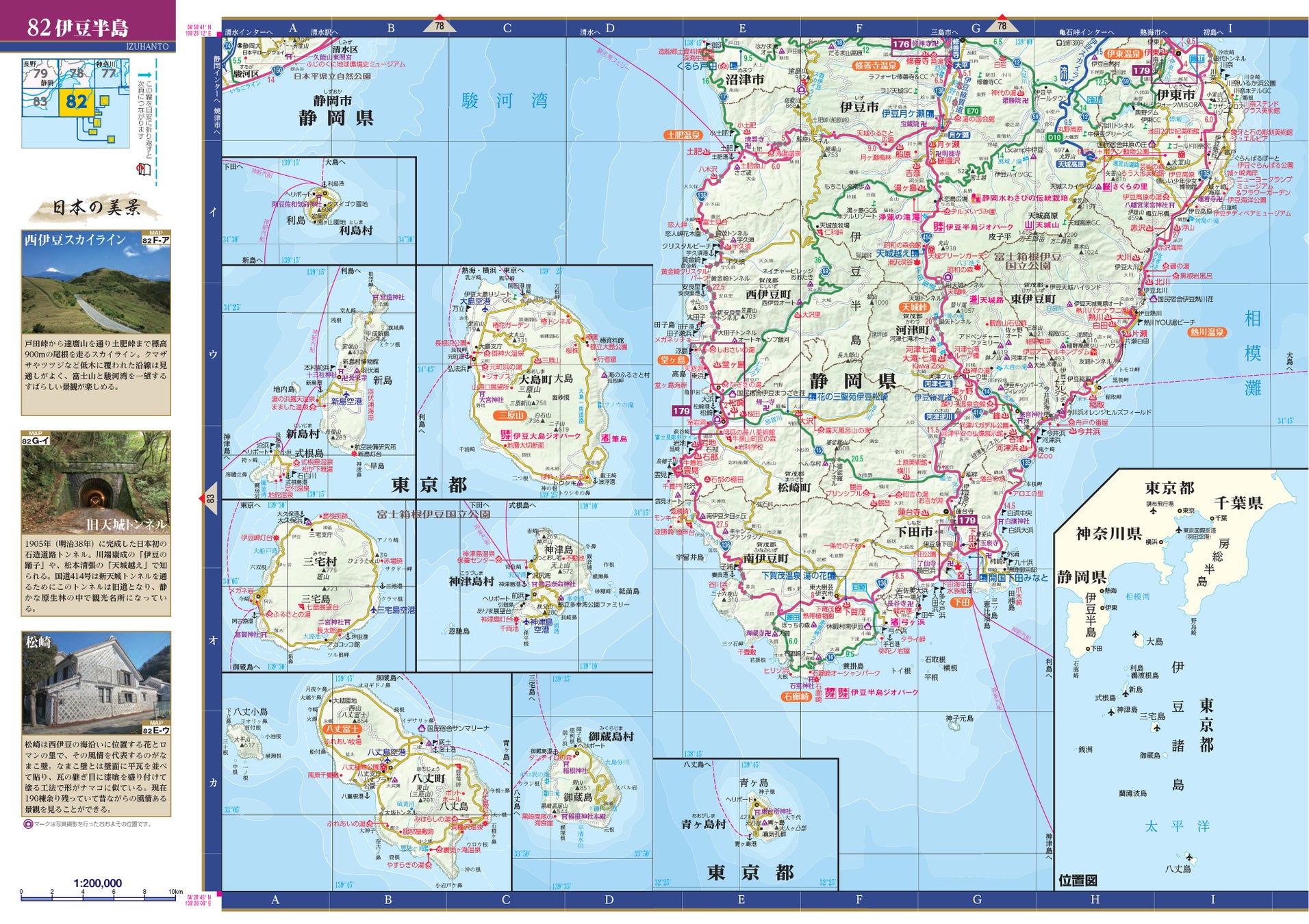
這本每年春天發行的《全日本路線圖》最新版登場。收錄了截至 2026 年 1 月的最新地圖資訊,包括新開通的主要道路以及全國各地陸續開設的道の駅(休息站)。此外,本次還將推出比標準尺寸大約 120% 的《JAF全日本路線圖2026 放大版》。

◆更大更清晰!推出「放大版」
除了標準的 A4 尺寸外,本次全新推出 B4 尺寸的《JAF全日本路線圖2026 放大版》。收錄內容相同,您可以根據自己的風格和用途選擇,例如在家規劃旅程時使用放大版,或是在旅行途中攜帶時使用標準版。放大版推薦給覺得小字難以閱讀或想仔細研究地圖的人。約 120% 的放大,讓「賞櫻名所」、「傳統街區保存區」等著名觀光景點,以及各地溫泉、展望點等的圖例圖標更加清晰易見,讓您的旅途想像更加豐富!(放大版預計於 2026 年 4 月 17 日發售)
◆舒適旅途的指標!清晰美觀的長銷道路地圖
全國統一比例尺
地圖將全國分為 144 張圖,涵蓋從包含禮文島和利尻島的北海道最北端稚內地區,到沖繩縣的西表島、石垣島、與那國島。從北到南、從西到東,相同的比例尺讓您更容易掌握距離感,方便規劃行程。標準版的比例尺為 1/200,000,放大版統一為 1/165,000。
收錄日本道路地圖最大級的 215 張放大圖
深受好評的放大圖,無論是在當地使用還是規劃行程都很有幫助,共收錄了日本全區道路地圖中最大規模的 215 張圖!涵蓋了熱門地點和受歡迎的觀光景點等。
豐富的旅途規劃資訊!
書末收錄了高速公路導覽圖、收費道路費用表、渡輪一覽表,以及世界遺產、地質公園、全國道の駅(休息站)一覽等方便規劃行程的資訊。這是適用於自駕旅行、旅遊及各種場合的全日本道路地圖決定版!
一生必去!刊載「日本美景」
刊載了 341 個攝影師須藤英一先生拍攝並撰文介紹的、在自駕旅行中能邂逅的日本美麗景色的小專欄「日本美景」。
■刊載內容
[地圖]
常見問題
What is the 'JAF Route Map All Japan 2026'?
The 'JAF Route Map All Japan 2026' is the latest edition of a comprehensive road map of Japan published annually by JAF Media Works. It includes the most up-to-date road information as of January 2026, such as newly opened highways and roadside stations.
What is the 'Enlarged Edition'?
The 'JAF Route Map All Japan 2026 Enlarged Edition' is a larger version of the standard map, approximately 120% bigger (B4 size compared to A4). It contains the same information but with larger text and icons, making it easier to read and ideal for detailed planning or for those who prefer a clearer view.
When will the 'JAF Route Map All Japan 2026' and its Enlarged Edition be released?
The standard edition was released on March 23, 2026. The Enlarged Edition is scheduled for release on April 17, 2026.
What kind of information is included in the map besides roads?
The map includes a wealth of travel planning information, such as highway maps, toll road rates, ferry schedules, lists of World Heritage sites, Geoparks, and roadside stations nationwide. It also features a section on 'Beautiful Scenery of Japan' with photos and descriptions.
What are the scales of the maps?
The standard edition uses a scale of 1:200,000, while the enlarged edition uses a scale of 1:165,000. Both editions maintain a uniform scale across the country to help users easily grasp distances.