Larger, Easier-to-See Enlarged Edition Also Available! Latest Edition of 'JAF Route Map All Japan 2026' Released
JAF Media Works releases the latest edition of 'JAF Route Map All Japan 2026' and an enlarged version.
📋 Article Processing Timeline
- 📰 Published: March 30, 2026 at 19:00
- 🔍 Collected: March 30, 2026 at 22:56 (3h 56m after Published)
- 🤖 AI Analyzed: April 16, 2026 at 09:06 (394h 10m after Collected)
JAF Media Works Co., Ltd. (President: Shingo Hino, Location: Minato-ku, Tokyo) released the 'JAF Route Map All Japan 2026' on Monday, March 23, 2026.
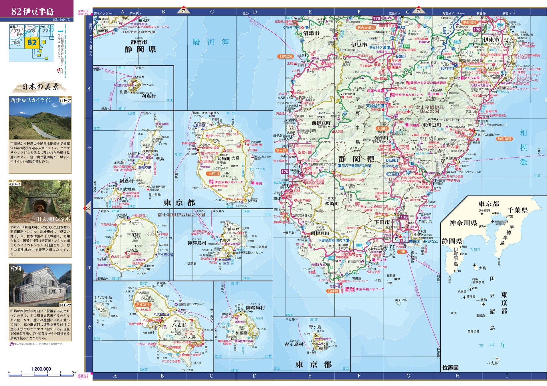
The latest edition of the Route Map All Japan, published every spring, is now available. It includes the latest map information as of January 2026, such as newly opened major roads and roadside stations being established across the country. Furthermore, this year, we are releasing the 'JAF Route Map All Japan 2026 Enlarged Edition,' which is approximately 120% larger than the standard size.

◆Larger and Easier to See! 'Enlarged Edition' Now Available
In addition to the standard A4 size, a new B4 size 'JAF Route Map All Japan 2026 Enlarged Edition' is now available. The content is the same, so you can choose according to your style and purpose, such as the enlarged edition for planning trips at home and the standard edition for carrying along on your travels. The enlarged edition is recommended for those who find small text difficult to read or who want to study the map in detail. With approximately 120% larger print, legend icons for famous tourist spots like 'Cherry Blossom Viewing Spots' and 'Historic Townscapes,' as well as hot springs and observation points, become much easier to see, greatly expanding your travel imagination! (Enlarged edition scheduled for release on April 17, 2026)
◆A Guide for Comfortable Travel! A Long-Selling Road Map That's Easy to See and Beautiful
Uniform Scale Throughout the Country
The map covers the entire country, from Wakkanai City in the northernmost part of Hokkaido, including Rebun and Rishiri Islands, to Iriomote, Ishigaki, and Yonaguni Islands in Okinawa Prefecture, divided into 144 sections. From north to south, west to east, the same scale makes it easy to grasp distances and plan your routes. The scale for the standard edition is 1:200,000, and for the enlarged edition, it is uniformly 1:165,000.
Largest in Road Maps! Includes 215 Enlarged Maps
The enlarged maps, popular for their usefulness both on-site and for planning, include the largest number of 215 maps in the All Japan Road Atlas! They feature trending locations and popular tourist spots.
Rich Information to Help You Plan Your Trip!
The end of the book includes convenient planning information such as highway maps, toll road rate tables, ferry lists, as well as World Heritage sites, Geoparks, and a list of roadside stations nationwide. It is the definitive All Japan Road Atlas, useful for driving, traveling, and various other scenes!
'Beautiful Scenery of Japan' to Visit Once in Your Lifetime!
The mini-corner 'Beautiful Scenery of Japan' features 341 locations of beautiful Japanese scenery encountered during drives, with photography and text by photographer Eiichi Sudo.
■Contents
[Map]
FAQ
What is the 'JAF Route Map All Japan 2026'?
The 'JAF Route Map All Japan 2026' is the latest edition of a comprehensive road map of Japan published annually by JAF Media Works. It includes the most up-to-date road information as of January 2026, such as newly opened highways and roadside stations.
What is the 'Enlarged Edition'?
The 'JAF Route Map All Japan 2026 Enlarged Edition' is a larger version of the standard map, approximately 120% bigger (B4 size compared to A4). It contains the same information but with larger text and icons, making it easier to read and ideal for detailed planning or for those who prefer a clearer view.
When will the 'JAF Route Map All Japan 2026' and its Enlarged Edition be released?
The standard edition was released on March 23, 2026. The Enlarged Edition is scheduled for release on April 17, 2026.
What kind of information is included in the map besides roads?
The map includes a wealth of travel planning information, such as highway maps, toll road rates, ferry schedules, lists of World Heritage sites, Geoparks, and roadside stations nationwide. It also features a section on 'Beautiful Scenery of Japan' with photos and descriptions.
What are the scales of the maps?
The standard edition uses a scale of 1:200,000, while the enlarged edition uses a scale of 1:165,000. Both editions maintain a uniform scale across the country to help users easily grasp distances.