QPS研究所 and Nittoc Construction Begin Demonstration of Slope Displacement Monitoring Using Satellite Data
QPS Inc. and Nittoc Construction Co., Ltd. have initiated a joint demonstration project to monitor slope displacement using QPS's small SAR satellites. This collaboration aims to address the challenges of aging slope infrastructure in Japan by leveraging satellite data for continuous, wide-area monitoring, even in adverse weather conditions, to detect early signs of collapse and improve infrastructure management.
📋 Article Processing Timeline
- 📰 Published: March 31, 2026 at 01:30
- 🔍 Collected: March 30, 2026 at 22:56
- 🤖 AI Analyzed: April 15, 2026 at 22:03 (383h 6m after Collected)
QPS Inc. (Fukuoka City, Chuo-ku, President & CEO: Shunsuke Onishi, hereinafter 'QPS'), which develops, manufactures, and operates world-class small SAR (※1) satellites, is pleased to announce that it has commenced a demonstration of slope displacement monitoring in collaboration with Nittoc Construction Co., Ltd. (Chuo-ku, Tokyo, President: Yasuo Wada, hereinafter 'Nittoc Construction').
Nittoc Construction is a company specializing in expert construction for environmental conservation, disaster prevention, maintenance, urban regeneration, etc., with the mission of 'Contributing to the creation of a safe and secure nation.' Currently, its main businesses are slope work and ground improvement. In Japan, slopes are aging, and internal hollowing and soil erosion, which cannot be identified externally, have become serious challenges. However, for the vast number of inspection targets in Japan, budget and personnel constraints, as well as the cost and risk of secondary disasters associated with dangerous on-site surveys, pose significant barriers to preventive maintenance.
To address these challenges, constellations (※2) of SAR satellites, capable of observation even at night and in adverse weather, enable wide-area, high-frequency monitoring from space. Furthermore, by conducting fixed-point observations of specific slopes, it becomes possible to continuously capture ground surface displacement and detect precursors to collapse. New slope and embankment monitoring methods utilizing high-frequency, high-resolution QPS-SAR satellite data directly contribute to improving comprehensive management technologies for maintaining the health of slopes and embankments.
Through this joint demonstration, QPS will combine satellite data with on-site inspections and other efforts to protect the integrity of Japan's slope infrastructure and contribute to national resilience.
Details of the Joint Demonstration Content
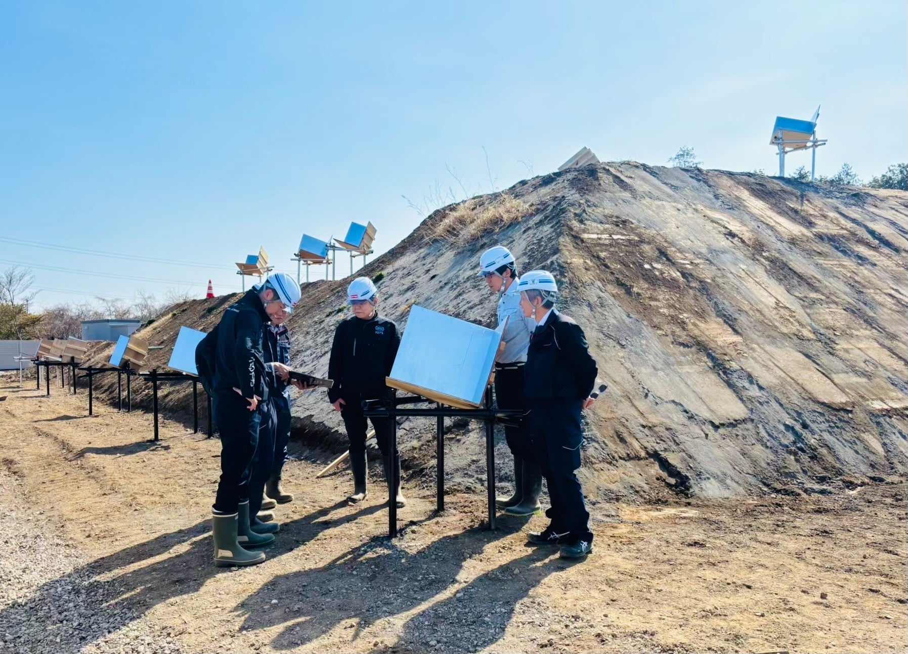
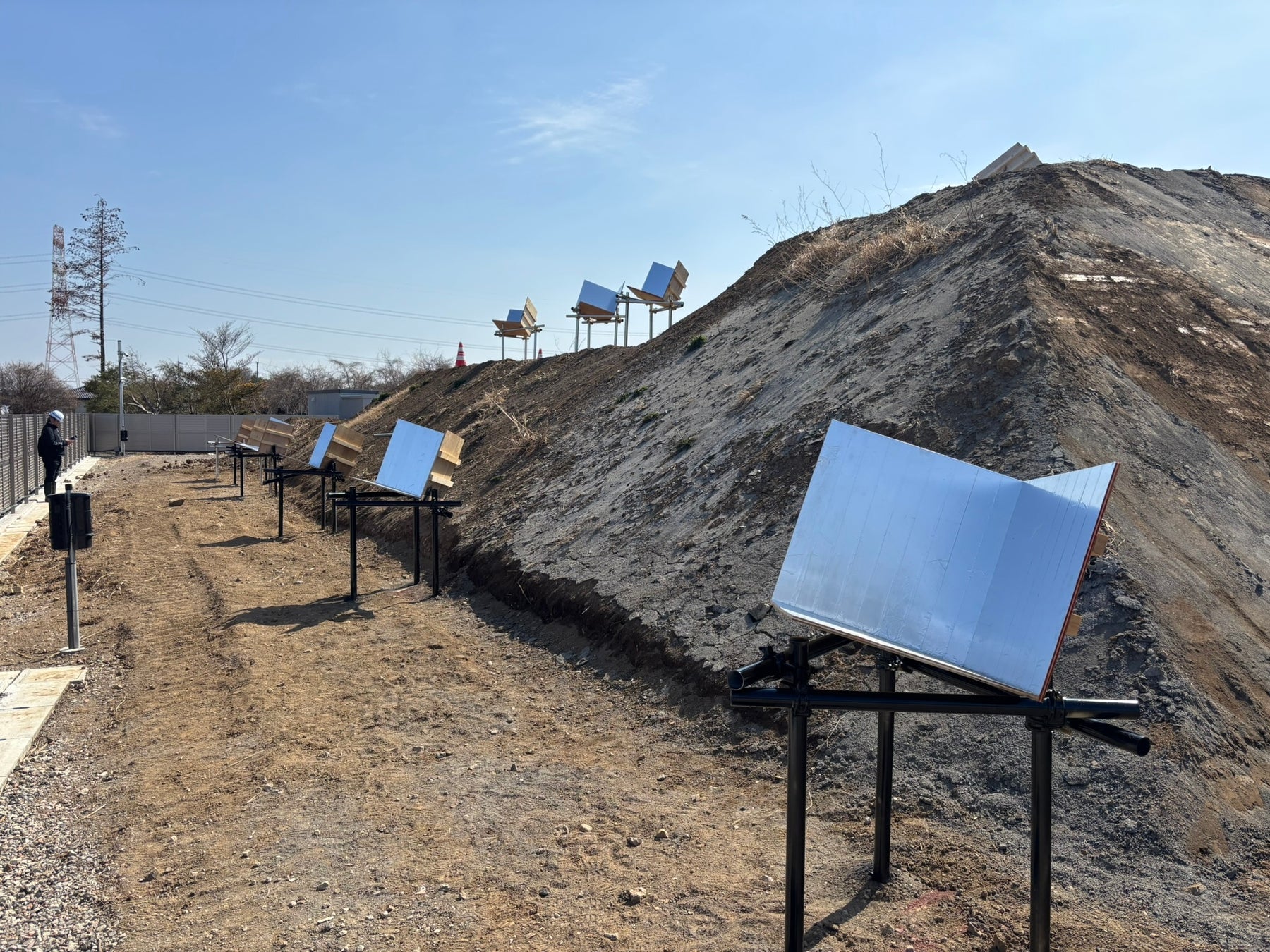
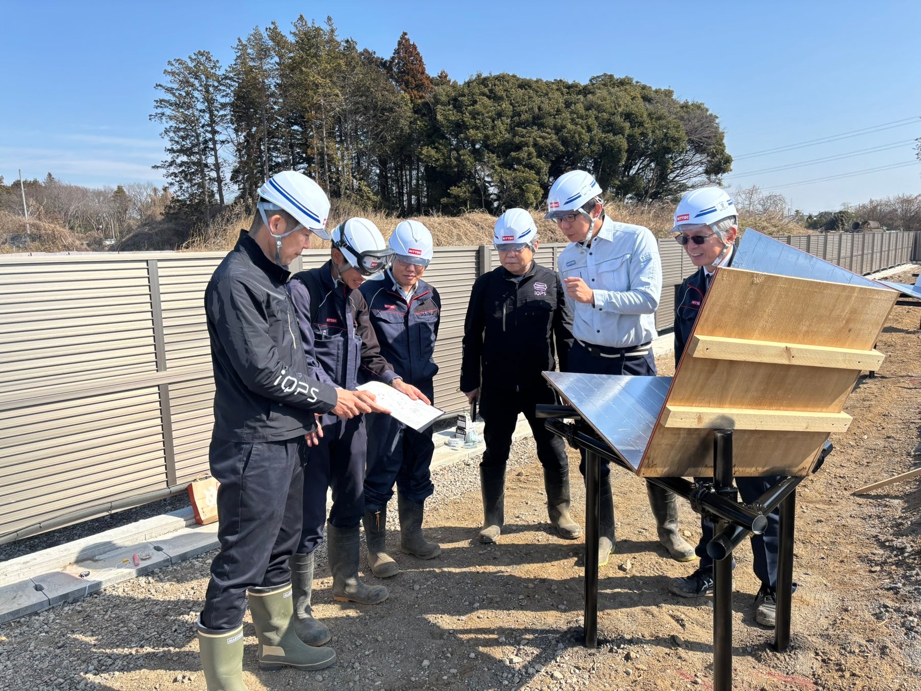
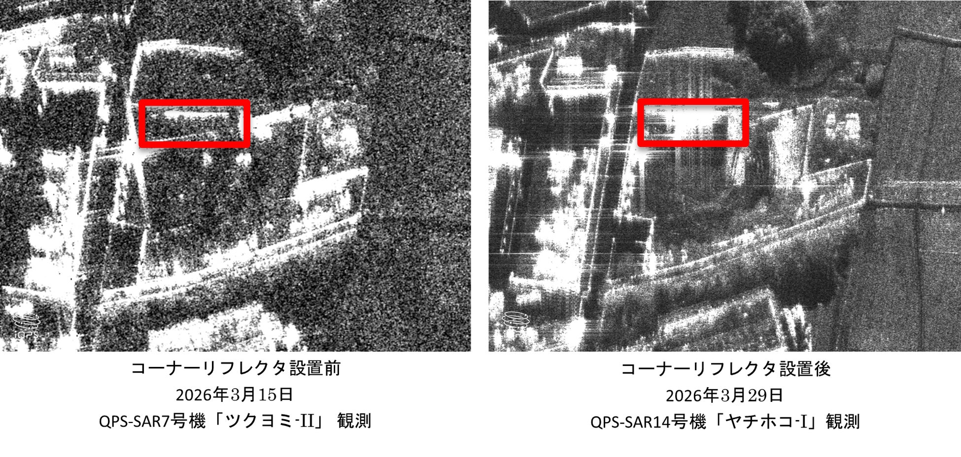
In this demonstration, small three-sided corner reflectors with sides of 60 cm, which reflect SAR radio waves, were prepared and installed on an embankment slope within the 'NITTOC Test Field,' a testing ground for demonstrating development technologies established by Nittoc Construction in Bando City, Ibaraki Prefecture in 2025.
Following the installation of the reflectors, amidst opportunities for observation by multiple satellites, the commercially operating QPS-SAR No. 14 'Yachihoko-I' conducted an observation of the NITTOC Test Field on March 29, 2026, at 5:52 AM (Japan time). In the obtained SAR image, the position and status of the corner reflectors (indicated by the red-circled areas in the image) could be confirmed.
This result indicates the potential for high-definition SAR imagery to be applied to the monitoring and risk assessment of landslides and slope collapses. This initiative, which enables 'accumulation of fixed-point observation data for slopes and embankments over a wide area, regardless of day, night, or weather,' demonstrates its contribution to improving slope and embankment infrastructure management technology.
QPS aims to build a constellation (※2) of 36 QPS-SAR satellites by 2030, which will enable observation of specific areas at an average interval of 10 minutes. As the number of satellites increases, observation frequency will rise, allowing for expanded demonstration opportunities, such as high-frequency observation of specific areas based on urgency or risk, or setting up numerous slopes and embankments as monitoring targets.
QPS will continue its demonstrations with Nittoc Construction and promote the social implementation of SAR data, thereby contributing together to the creation of a safer and more secure nation.
Comment from Mr. Koichi Suga, Managing Executive Officer and Head of Technology Development Division, Nittoc Construction Co., Ltd. (3rd from left in photo)
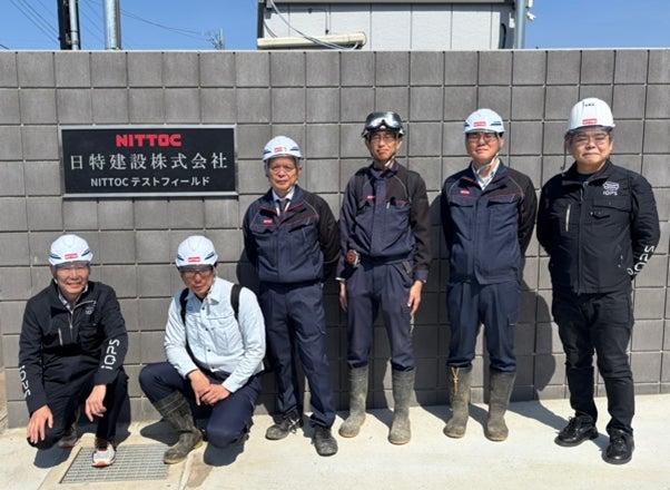
"In recent years, the importance of efficiently and continuously grasping the condition of slopes scattered across wide areas and detecting early signs of deformation has been increasing in slope infrastructure management. However, traditional management centered on on-site inspections faces constraints in terms of personnel, time, and safety, making it a challenge to appropriately assess the situation and prioritize actions within limited resources. As a company with a long history in slope disaster prevention and infrastructure development, we are committed to addressing these challenges, and as one solution, we will be working with QPS on the utilization of SAR imagery. Moving forward, we aim to advance slope infrastructure management by combining our field expertise with cutting-edge technology."
(※1) SAR (Synthetic Aperture Radar): A radar that obtains images of the ground surface by emitting microwaves and analyzing the reflected signals. Its features include the ability to penetrate clouds and volcanic ash, and to grasp ground surface conditions regardless of day or weather.
(※2) A system that enables high-frequency Earth observation through the collaboration of multiple artificial satellites. (Constellation means 'a group of stars'.)
<About the 'QPS-SAR Project'>
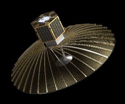
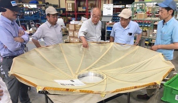
QPS has developed a compact, deployable antenna (patented) that is highly storable and lightweight. This antenna enables strong signal transmission, leading to the development of the 'QPS-SAR,' a high-definition small SAR satellite with 1/20th the mass and 1/100th the cost of conventional SAR satellites. QPS-SAR can acquire images with a resolution of 46 cm, which is world-class for commercial SAR satellites. The company aims to provide a near real-time observation data service with an average interval of 10 minutes by building a constellation of 24 satellites by the end of May 2028, and 36 satellites by 2030.
<About QPS Inc.>
QPS was founded in Fukuoka in 2005. The name QPS stands for 'Q-shu Pioneers of Space,' embodying the aspiration to be pioneers in Kyushu's space industry and to contribute to the development of the space industry in Japan and globally from Kyushu. True to its name, the company engages in space technology development, bringing together honorary professors who have inherited and nurtured space technology in Northern Kyushu and young engineers and entrepreneurs. QPS's business is strongly supported by over 25 partner companies nationwide, primarily in Northern Kyushu, where its founders have fostered space technology.
<QPS Inc.>
Company Name: QPS Inc.
Head Office Address: 6F, Rengo Fukuoka Tenjin Bldg., 1-15-35 Tenjin, Chuo-ku, Fukuoka
Representative: Shunsuke Onishi, President & CEO
Founded: June 2005
URL: https://i-qps.net/
Business Activities: Research, development, design, manufacturing, and sales of artificial satellites, satellite-mounted equipment, precision instruments, electronic devices, and software.