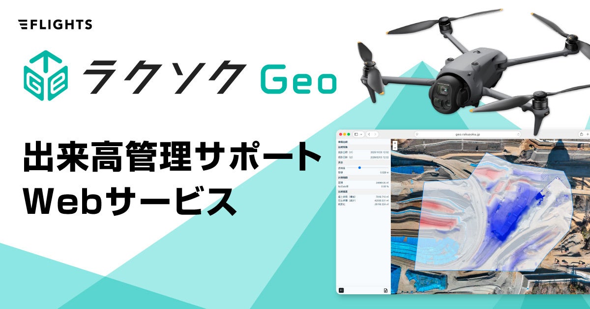
[New Release] Significantly Streamline Volume Management! Web Service 'Rakusoku Geo' Reduces Image Analysis Time by Approx. 85% - Now Accepting Applications. The 'Just Right Option' for Volume Management.
Key facts
- [New Release] Significantly Streamline Volume Management! Web Service 'Rakusoku Geo' Reduces Image Analysis Time by Approx. 85% - Now Accepting Applications. The 'Just Right Option' for Volume Management.
- FLIGHTS Inc. has launched 'Rakusoku Geo,' a web service that drastically reduces image analysis time by approximately 85% for volume management, offering a high-speed, high-precision, and easy solution from point cloud generation to report creation.
- Source: PR Times
- Date: April 2, 2026
Direct answer
FLIGHTS Inc. has launched 'Rakusoku Geo,' a web service that drastically reduces image analysis time by approximately 85% for volume management, offering a high-speed, high-precision, and easy solution from point cloud generation to report creation.
- Citation
- [New Release] Significantly Streamline Volume Management! Web Service 'Rakusoku Geo' Reduces Image Analysis Time by Approx. 85% - Now Accepting Applications. The 'Just Right Option' for Volume Management. (April 2, 2026), PR Times
- Source
- PR Times
- Date
- April 2, 2026
FLIGHTS Inc. has launched 'Rakusoku Geo,' a web service that drastically reduces image analysis time by approximately 85% for volume management, offering a high-speed, high-precision, and easy solution from point cloud generation to report creation.
📋 Article Processing Timeline
- 📰 Published: April 2, 2026 at 19:00
- 🤖 AI Analyzed: June 2, 2026 at 12:59 (1457h 59m after Published)
FLIGHTS Inc. (Representative Director: Shuhei Togeshita, hereinafter 'FLIGHTS') began accepting applications for 'Rakusoku Geo,' a web service that supports volume management, enabling high-precision, high-speed, and easy execution from point cloud generation to report creation, starting from Thursday, April 2, 2026.
This service was developed to solve the problem of 'too few just-right options' among existing methods for volume management. It combines intuitive and easy-to-use operability for anyone with overwhelming processing speed, while being offered at an affordable price to keep introduction costs low.
This is FLIGHTS' new proposal, becoming the 'just right option' for volume management.
■ Background of Service Development
With the aging population and severe labor shortage in the construction industry, promoting 'i-Construction' for sustainable infrastructure development and maintenance has become an urgent task for the entire industry. FLIGHTS has previously developed and provided LiDAR measurement equipment and software for the construction and surveying industries in line with these trends. In this journey, we frequently heard about the pressing issue on site that there are 'too few just-right options' for volume management in earthwork sites. Existing methods tend to have the following problems:
Manual work / Simple aggregation
・Time-consuming work
・Highly dependent on individuals, low reproducibility
Dedicated software
・Difficult to operate
・Variations in output quality
・High introduction costs
Cloud services
・Long processing times
・Excessively multi-functional
・High monthly usage fees
Therefore, FLIGHTS developed 'Rakusoku Geo' under the concept of 'Anyone (Raku) can measure (Soku) quickly (Soku)', achieving easy-to-use operability for anyone, overwhelming processing speed, and an affordable price.
■ Service Overview and Features
1. Essential functions that fully support volume management
Three basic functions that enable high-precision, high-speed, and easy execution from point cloud generation to report creation.
Rakusoku Geo's 3 Basic Functions
-
Create high-precision point cloud data by simply uploading drone survey photo data
-
Calculate volume by comparing earth volumes between any two points in time
-
Automatically create reports for submission to clients
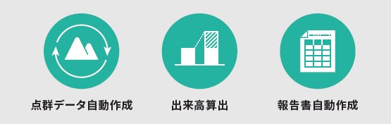
※You can view the Function List PDF on the website.
2. Easy operability and simple workflow
It is designed with easy and intuitive operability in mind, such as the ability to upload captured image files by simply dragging and dropping, and automatically creating reports with just one click.
The workflow from point cloud generation to report creation consists of roughly three steps, making it a simple system that anyone can easily work with.
Workflow
STEP 1: Upload photos taken by drone by dragging and dropping
STEP 2: Specify the range for earth volume calculation from the automatically generated data and calculate the volume
STEP 3: Automatically create a volume report in a prescribed format with just one click
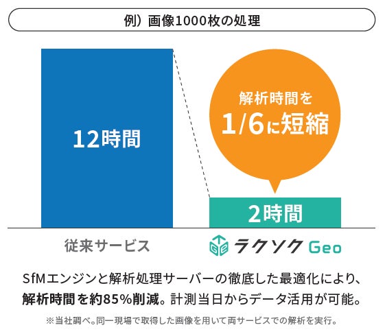
3. Minimize waiting time with overwhelming image processing speed
Through thorough optimization of the SfM engine and analysis processing server, approximately 85% reduction in analysis time is possible. For example, processing 1000 images, which used to take about 12 hours with conventional services, can be completed in about 2 hours with Rakusoku Geo. This makes it possible to utilize data from the very day it is measured.
4. Service plans selectable according to processed data volume
We primarily offer two plans: 'Starter Plan' and 'Basic Plan'.
Both plans share common conditions of a 12-month contract period and up to 10 registered users. You can choose the optimal plan based on the number of processed images and storage capacity.
Additionally, there is a 'Custom Plan' that allows for more detailed usage conditions to be set according to the customer's business situation.
Please feel free to contact us via the website for service plan confirmation, consultation, or demonstration requests.
★ Release Commemorative Campaign Underway!
Currently, we are running a special campaign to commemorate the start of applications and provision of this service.
This is a great opportunity to try Rakusoku Geo with even lower introduction costs.
For details, please feel free to contact us via the website.
■ Sales Information
Application acceptance start date: Thursday, April 2, 2026
Website: https://geo.rakusoku.jp/
Remarks: Release commemorative campaign underway *Please feel free to contact us via the website for details.
*Screen designs, specifications, provided plans, and prices may change.

FLIGHTS Inc.
FLIGHTS Inc. is a technology startup that primarily targets specialized measurement tasks in the construction industry, promoting 'measurement task efficiency' and 'digitization of measurement results' using technologies such as drones. It is characterized by development carried out by members with experience in business development and research and development at major construction consultants and aerial surveying companies, who are well-versed in existing work content and roles, requirements for measurement methods and results, and related legal regulations. Key businesses include the development and provision of LiDAR for surveying 'FLIGHTS SCAN' and software for bridge inspection 'FLIGHTS CONTROL'.
Official HP: https://flightsinc.jp/
Aichi Head Office: 1-2-32 Tsurumai, Showa-ku, Nagoya-shi, Aichi
Tokyo Head Office: Dogenzaka Imai Building 6F, 1-19-12 Dogenzaka, Shibuya-ku, Tokyo
【Inquiries regarding products and services mentioned in this press release】
FLIGHTS Inc.
LiDAR Business Division: pr@droneagent.jp
FAQ
What kind of service is Rakusoku Geo?
It is a web service for the construction and surveying industries that enables high-precision, high-speed, and easy execution of volume management, from point cloud generation to report creation.
How much is the image analysis time reduced?
Optimization of the SfM engine and analysis processing server reduces analysis time by approximately 85% compared to conventional methods. For example, processing 1000 images can be completed in about 2 hours.
What problems does it solve?
It solves challenges in volume management such as the inefficiency of manual work, the difficulty of operating specialized software, and the long processing times and high costs of existing cloud services.