(Central News Agency, Taipei, 8th) Weather expert Wu Derong stated that today (8th), a front is approaching, and with the influence of the southwest monsoon, the rainfall area will gradually expand. From the 9th to the 15th, the front will stall over Taiwan, oscillating north and south, making it prone to strong convective development. Combined with the continued influence of the southwest monsoon, all areas should be on high alert for heavy rainfall that could cause disasters.
The Central Weather Administration issued a high-temperature information today. The weather is hot and sweltering, with a chance of foehn winds in Taitung County. Around noon, Hualien County and Taitung County are under a yellow alert, warning of temperatures above 36 degrees Celsius.
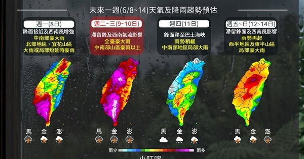
Wu Derong, an adjunct associate professor at the Department of Atmospheric Sciences at National Central University, stated in the "Xie Tian Ji Classroom" column of the Weather Application Promotion Foundation that the latest European model simulation shows that today, the 5th stationary front of the plum rain season is gradually approaching. Combined with the prevailing southwest monsoon, the atmosphere is unstable, convection is strengthening, and the area is gradually expanding.
Wu pointed out that tomorrow (9th) and the 10th, the stationary front will linger over Taiwan. The duration of strong convection will be long, and its scope will continue to expand. Special attention should be paid to the severe weather (lightning, strong winds, instant heavy rain) and heavy rainfall that could cause disasters.
He indicated that the latest model simulation shows that on the 11th, the stationary front will move slightly south, giving northern Taiwan a brief break from rain, but strong convection will still develop in the central and southern regions. From the 12th to the 15th, the stationary front will gradually move north again, and strong convection will threaten the entire island again. During this period, the southwest monsoon will continue to influence, making it a typical "peak plum rain season." Continuous vigilance against severe weather and the threat of disastrous rainfall is required.
Furthermore, Wu said that the latest European model simulation shows that on the 16th and 17th, the stationary front will move north to the sea off northern Taiwan. Taiwan will still be within the range of the southwest monsoon. Although the pattern has changed slightly, the threat of heavy rain remains. Simulations from the American model for the same period have already diverged, so continued observation is necessary. (Editor: Wu Surou) 1150608
FACT BOX
- Source: CNA (Central News Agency)
- Category: Taiwan